Custom Integrations
Making LIDAR systems, film and digital cameras, GPS receivers and inertial measurement units (IMUs) as well as flight management systems work smoothly together is our expertise. Tight aircraft spaces are no novelty to us and neither is being baked, or frozen, inside them. We know how important it is for software and hardware to communicate properly, but also to tailor required operator interaction to an overall convenient minimum while airborne.
Data Processing
If you have a troublesome GPS data or IMU gaps that do not want to process or give bad results, we can help.
During our long experience in first-line customer support we almost exclusively dealt with challenging data and you can benefit from that to save your mission.
We not only process your troublesome data, but also advise you on the likely cause for the problem and how you can avoid it in the future.
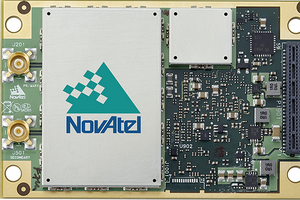
NovAtel GPS/IMU Technology
Frontier Geomatics Inc. is a full-service NovAtel SPAN representative for airborne mapping.
SPAN is a positioning and attitude measurement system consisting of a GPS receiver and an inertial measurement unit (IMU).
A GPS/IMU system does not have to be exclusive for scientists any more and is simple to operate.
After all, it is just an aiding sub-system for your overall mapping projects.
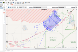
TerraPOS
Precise Point Positioning
TerraPOS is a GPS post-processing software that delivers better than 5 cm positional accuracy of an airborne kinematic trajectory without base station. It works anywhere in the world. This software suite is based on the principle of Precise Point Positioning and has been developed by TerraTec of Norway, initially for their in-house use.
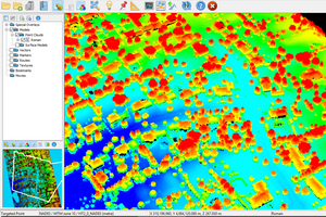
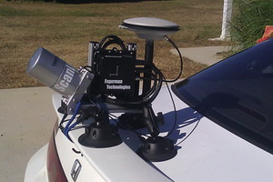
LiDAR
Mobile Mapping
ScanLook 2.0, otherwise known as SNOOPY, is the latest development by Fagerman Technologies Inc. SNOOPY brings a significant reduction in size while at the same time offering an increase in scanner and INS configurations. SNOOPY can be tailored for your application whether it is scanning rails, bridges, shorelines, power lines, roads, assets, etc.