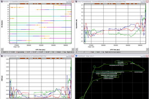
If you have a troublesome GPS data or IMU gaps that do not
want to process or give bad results, we can help. During our long experience
in first-line customer support we almost exclusively dealt with challenging
data and you can benefit from that to save your mission. We not only process
your troublesome data, but also advise you on the likely cause for the
problem and how you can avoid it in the future.
With NovAtel’s Inertial Explorer we can process
NovAtel SPAN data, POSAV and IGI’s AeroControl including output of photo
centers in a multitude of datums and map projections.
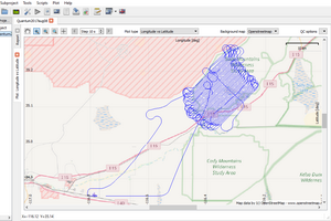
Should you have a project with a malfunctioning GPS base station we
can process your airborne data to cm-level accuracy with TerraTec’s
TerraPOS software no matter which year or in
which country your mission was flown.
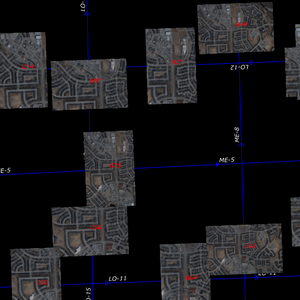
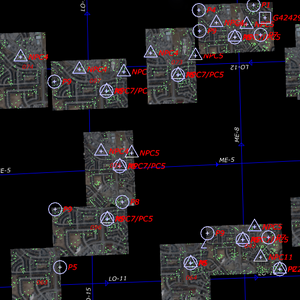
Frontier Geomatics also provides aerial triangulation services with point
measurements, bundle adjustment for standard photogrammetric projects and
IMU-to-Camera boresighting.
We use Inpho’s Match-AT and offer following capabilities:
- ABGPS/IMU processing and EO-input for AT point matching from SPAN, Aerocontrol, IPAS and POSAV systems
- Imagery from Z/I DMC, Leica ADS, metric digital cameras and scanned large-format photography
- Direct import of Intergraph, Socet Set and DAT/EM projects
- Full tie-point matching with Inpho's MATCH-AT with blunder detection and thorough manual data cleaning
- Data export to PATB, Bingo, BLUH, Socet Set, Z/I projects, DAT/EM Summit Evolution, Pex2, Phorex Phocus and various analytical stereo-plotters
- Full report on results with analysis of input data as well as achieved accuracies
We also boresight your camera to your IMU and issue a Boresight Certificate
with resulting angles and their standard deviations.